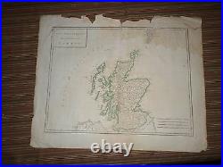
Rare Antique Map of Scotland (Isles Britanniques) Early 19th century
January 19, 2022


Up for sale is a nice Copper Engraved map published in Mentelle & Chanlaires. A rare antique, colored map this is a full page map (two pages with crease down center) from the atlas measuring approximately 19 by 16 inches. Published early 19th century. Overall map is in acceptable condition. A few small rips down the right side of the map. There is a large light stain in the top right corner. There are several small rips and light staining along the left edge. There are also several rips along the bottom and right edges. There is one 1 inch tear along the crease on the bottom, but does not affect the print of the map. The top has a lot of rips toward the center, and a lot of the paper is folded over and very fragile. There is also one 1.5 inch tear along the top crease extending slightly into the map. There is one large crease down the middle where the originally two page map was attached and folded. Most rips and tears on this map do not extend beyond the boarder area into the map. Other chipping at edges, small dings and nicks here and there mostly impacting boarder area. The back of this map is blank. Map has been stored flat. Map will look great framed. This item is in the category “Antiques\Maps, Atlases & Globes\North America Maps”. The seller is “book14850″ and is located in this country: US. This item can be shipped worldwide.
